Yutong Jiang
I'm Designer
About
Hello there, my name is Yutong Jiang, I'm a graduate student from University of Pennsylvania, I'm majoring geographic information system. I study, explore and create map, and geospatial data science.
.JPG)
Geospatial Data Science
- Phone: 6086986722
- Programming Skills: R, python, java, html, css, java script, postgreSQL, leaflet.js, D3.js, react, pandas
- GIS Analysis Skills: ArcGis Pro, ArcGis online, ArcMap, qgis, open street map, arcgis story map, Google Earth Engine, CloudCompare, ENVI, meshroom
- Base: Philadelphia, PA
- Email: jiangyutong018@outlook.com
Courses: Programming for Geocomputing & Geospatial Big Data Analysis; Graphic Design and Storytelling in Cartographic Representation; Web Programming for Interactive Cartography & Geovisualization; Spatial Database Design and Development; Application of GIS in Planning; Statistics & Quantitative Methods for Geocomputing; Spatial Point Cloud Data Application and Remote Scencing.
Personal CV
Download PDF Resume
Posts
GIS Analysis Report
Planning for resilience to natural hazards🌐
This story map highlights the intersection of wildfire vulnerability, natural hazards, social vulnerability, and community resilience. It serves as a comprehensive guide for understanding and addressing the complex challenges posed by wildfires. Key focus areas include:
- Natural Vulnerability: Explores how environmental conditions like drought, precipitation, and fuel availability exacerbate wildfire hazards.
- Social Vulnerability: Examines the socio-economic and demographic factors that influence a community’s ability to prepare for, respond to, and recover from wildfires.
- Community Resilience: Highlights strategies for strengthening community capacity to withstand and recover from wildfire events, including preparedness planning, infrastructure improvements, and equitable resource allocation.
Analyzing Parking Spaces in LA🌐
This project examines the distribution and utilization of parking spaces in Los Angeles, utilizing data analysis to provide insights into parking availability and usage patterns. Key highlights include:
Data Collection: Gathered comprehensive data on parking spaces across various neighborhoods in Los Angeles, including information on parking meters, public parking lots, and residential parking zones. Usage Patterns: Analyzed occupancy rates, peak usage times, and the impact of parking availability on traffic congestion in different areas. Recommendations: Proposed strategies for optimizing parking space allocation, improving signage, and implementing dynamic pricing to enhance parking efficiency and reduce congestion.
Geospatial Data Science Report
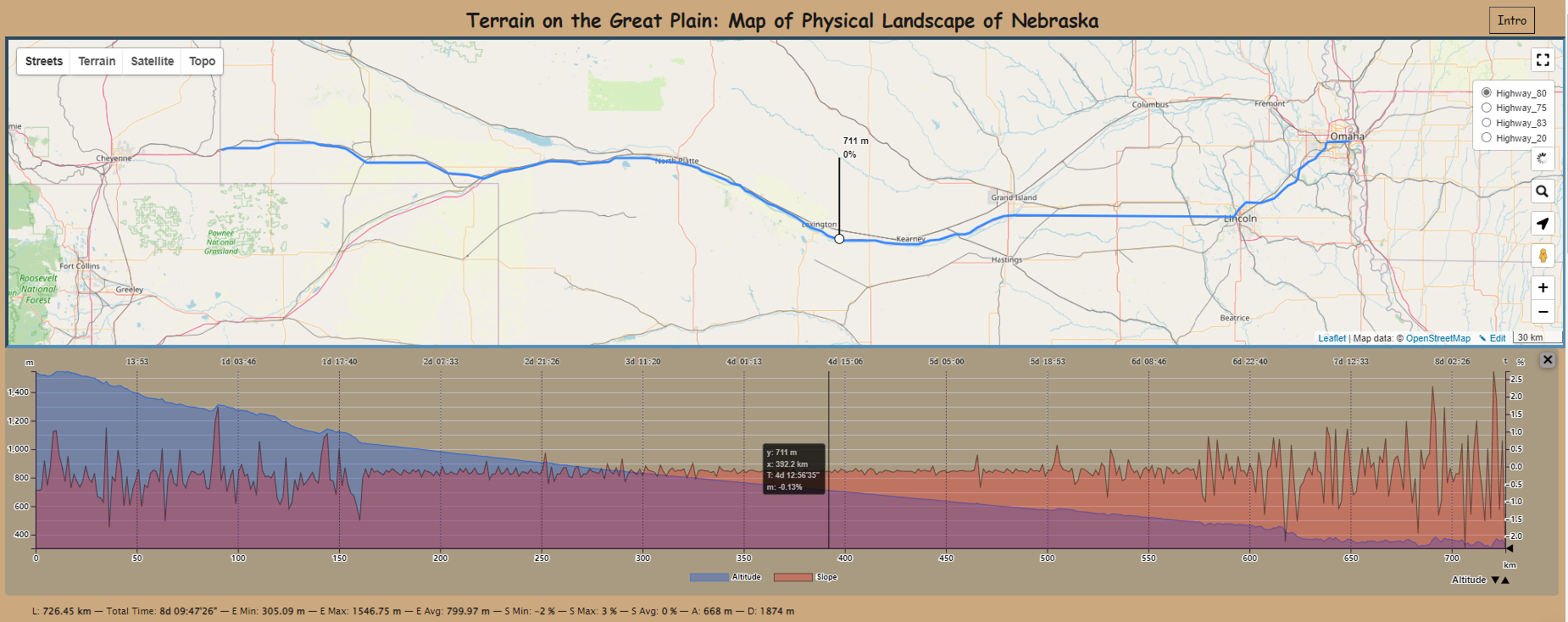
Train Delay Time Prediction for NJ Transit🌐
This report presents a comprehensive analysis of transit delay prediction, focusing on the development and evaluation of models to forecast delays in public transportation systems. Key components of the study include:
Data Analysis: Preprocessing transit data and identifying key delay factors like weather and time of day. Predictive Modeling: Development and evaluation of machine learning models to forecast delays. Insights: Actionable recommendations to enhance transit efficiency and reduce delays.
Predicting Bikeshare Demand in Jersey City🌐
This project explores Jersey City's bike share program, leveraging data to understand its usage and impact. Key highlights include:
Usage Patterns: Analysis of trip frequency, duration, and popular routes. Program Impact: Assessment of the bike share program’s role in promoting sustainable transportation, reducing traffic congestion, and enhancing connectivity in urban areas. Recommendations: Insights for optimizing station placement, improving user experience, and increasing accessibility for underrepresented groups.
Risk Predictions of Armed Robbery Incidents in Chicago🌐
This report provides a comprehensive assessment of risks in Chicago, leveraging data to identify vulnerabilities and propose actionable strategies. Key components include:
Risk Identification: Mapping areas at risk for hazards such as flooding, crime, and infrastructure vulnerabilities. Urban Resilience: Analyzing the city's preparedness and response strategies to enhance resilience against identified threats. Actionable Insights: Recommendations for improving urban planning, emergency response, and resource allocation to mitigate risks effectively.
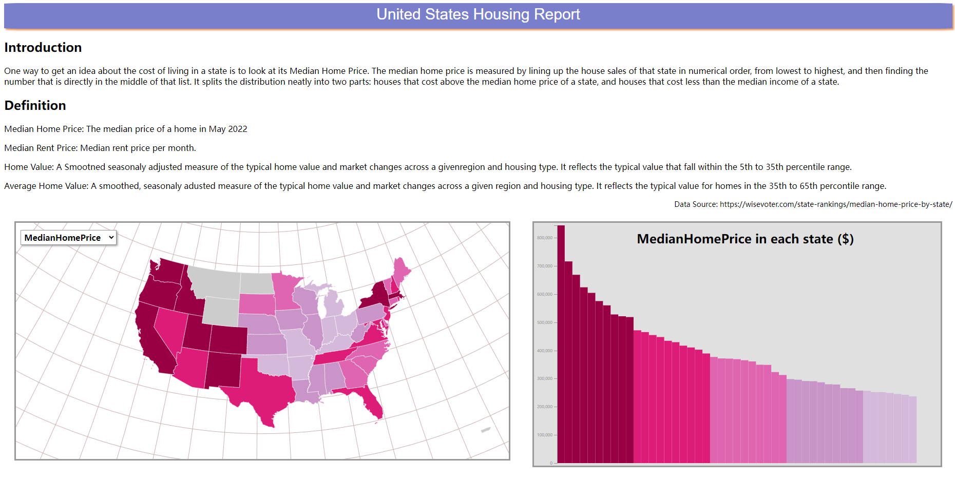
Improving Zillow's Housing Price Predictions in Philadelphia🌐
This report presents a focused evaluation of housing price prediction challenges in Philadelphia, leveraging local data to enhance Zillow's predictive model. Key components include:
Local Intelligence Integration: Incorporating neighborhood characteristics such as household income, housing condition, and proximity to amenities to improve prediction accuracy. Model Analysis:Applying OLS regression to explore relationships between variables and assess model performance, with findings indicating significant errors and limitations in capturing spatial patterns. Actionable Insights: Proposing advanced modeling techniques, additional demographic data, and spatial regression methods to refine predictions and address geographic disparities.